 Tessel libraries
Geodesy for Tessel programs: exact distances, azimuths and areas on the ellipsoid, rhumb lines, map projections, datum shifts, and coordinate systems by EPSG code, PROJ string or WKT, with degrees as text and MGRS. Geodesics are Karney's algorithms, as in GeographicLib, good to about 15 nanometres anywhere on the Earth. Projections and datum shifts follow PROJ, the engine of QGIS and GDAL, and agree with it to the nanometre for every one of the 5230 EPSG projected systems geodesy has: all of EPSG's but one 3D system.
import geodesy

fn main() {
    // Distances and bearings on WGS84 (Karney's geodesics).
    let r = geodesy.inverse(14.5995, 120.9842, 10.3157, 123.8854)     // Manila to Cebu
    print("{r.distance} m, setting off at {r.azimuth1}°")             // 569218.2057… m, 146.029…°

    // Coordinate systems by EPSG code, PROJ string or WKT.
    let wgs = geodesy.wgs84Crs()
    let zone3 = geodesy.epsg(3123) ?? wgs                               // PRS92 / Philippines zone 3
    let (e, n) = geodesy.transform(120.97695, 14.58285, from: wgs, to: zone3)
    print("{e} {n}")                                                  // 497369.807 1612820.042

    // Grid to ground: the scale factor and convergence there.
    let (lon, lat) = zone3.toLonLat(e, n)
    let (k, _, convergence) = zone3.gridFactors(lon, lat)
    print("k = {k}, convergence {convergence}°")                      // k = 0.99995009, -0.0061°

    // Degrees as text, and MGRS.
    print(geodesy.formatLatLon(14.58285, 120.97695))                  // 14°34'58.26"N 120°58'37.02"E
    print(geodesy.toMGRS(14.58285, 120.97695))                        // 51PTS8205113157

    // The area of a lot from the GPS readings at its corners.
    let (area, perimeter) = geodesy.polygonArea([14.58285, 14.58285, 14.58375, 14.58375],
                                                [120.97695, 120.97788, 120.97788, 120.97695])
    print("{area} m², {perimeter} m")                                 // 9979.24 m², 399.59 m
}
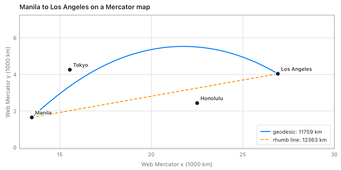
Using it
Add it to a project (Tessel 0.10 or later):
tessel add geodesy
then import geodesy. Latitudes and longitudes are in degrees; lengths in
metres. Points are (x, y): easting and northing, or longitude and latitude,
whatever order EPSG lists the axes in.
On the ellipsoid
| Function | Gives |
|---|---|
inverse(lat1, lon1, lat2, lon2, on:) |
The shortest path: distance, azimuth1 and azimuth2 (degrees clockwise from north), and its arc, reducedLength, scale12, scale21 and area to the equator. |
distance(lat1, lon1, lat2, lon2, on:) |
Just the length. |
direct(lat, lon, azimuth:, distance:, on:) |
The point that far along the geodesic, and the azimuth there. |
line(lat, lon, azimuth:), lineBetween(lat1, lon1, lat2, lon2) |
A GeodesicLine: position(distance) gives points along it, points(n) n evenly spaced ones, for drawing. |
polygonArea(lats, lons, on:) |
The area (m², positive counterclockwise) and perimeter of a polygon of geodesics: a lot, a province or a continent, round a pole or across 180°. |
trackLength(lats, lons, on:) |
The length of a GPS track. |
rhumb(lat1, lon1, lat2, lon2) |
The rhumb line (constant bearing): its length and azimuth. |
rhumbDirect(lat, lon, azimuth:, distance:), rhumbPoints(…, count:) |
Points along a rhumb line. |
on: is the ellipsoid: wgs84() unless you say, ellipsoid(a:, f:), or one
of PROJ's 46 by name: ellipsoidNamed("clrk66"), "GRS80", "intl",
"bessel", "airy"…
Coordinate systems
A Crs is latitude and longitude on a datum, or a projection of them, with
the datum's shift to WGS84.
| Function | Gives |
|---|---|
epsg(code) |
One of 578 geographic and 5230 projected EPSG systems, or nil: UTM, the Philippine zones of PRS92 (3121–3125) and Luzon 1911 (25391–25395), Web Mercator, US state planes, national grids… |
crs(text) |
From "EPSG:3123", a PROJ string, or WKT. |
fromProj(text) |
From a PROJ string, like +proj=tmerc +lat_0=0 +lon_0=121 +k=0.99995 +x_0=500000 +ellps=clrk66 +towgs84=…. |
fromWkt(text) |
From WKT1 (a shapefile's .prj, as GDAL or Esri write it) or WKT2. |
utm(zone:, south:), utmFor(lat, lon), utmZone(lat, lon) |
WGS84 UTM systems, with Norway's and Svalbard's zones. |
wgs84Crs() |
WGS84 latitude and longitude (EPSG:4326). |
epsgCodes(search:) |
The codes whose names contain a text: epsgCodes(search: "Philippines"). |
transform(x, y, from:, to:), transformAll(xs, ys, from:, to:) |
Points from one system to another. |
Crs method |
Gives |
|---|---|
toLonLat(x, y), fromLonLat(lon, lat) |
To and from longitude and latitude on its own datum. |
toWGS84(x, y), fromWGS84(lon, lat) |
To and from WGS84 longitude and latitude. |
gridFactors(lon, lat) |
The grid's scale along the meridian and the parallel, and the convergence (as PROJ's get_factors): for reducing ground distances to the grid. |
proj(), wkt() |
The system as a PROJ string, and as WKT1 for a .prj file. |
Projections: Transverse Mercator (by Krüger's series to 6th order, exact to nanometres), UTM, UPS, Mercator, Web Mercator, Lambert conformal conic (1SP, 2SP, variant B), Albers equal-area, polar, oblique and equatorial stereographic, oblique stereographic on the Gauss sphere (EPSG's), Lambert azimuthal equal-area, equidistant cylindrical, Cassini–Soldner (with EPSG's hyperbolic variant), Hotine oblique Mercator (EPSG's variants A and B, by two points, Malaysia's and Borneo's RSO, Michigan), Krovak (Czech and Slovak, either orientation), the Swiss oblique Mercator, American polyconic (Brazil), azimuthal equidistant (and Guam's), Lambert cylindrical equal-area (EASE-Grid), Equal Earth, Laborde (Madagascar), Colombia urban, and the New Zealand Map Grid.
A PROJ string's +axis gives directions only: x is the east or west value
and y the north or south one, so Krovak's +axis=swu is x west and y
south, as wsu.
Datum shifts are 7-parameter Helmert transformations through WGS84, as
PROJ does them: the one PROJ itself picks from the EPSG database for each
datum (418 of the 578), with its prime meridian where that differs (MGI
Ferro). A datum without one (shiftKnown false) is taken as WGS84, as
PROJ's "ballpark" does. PRS92's shift is EPSG's (good to about a metre);
Luzon 1911's is the one for the Philippines outside Mindanao.
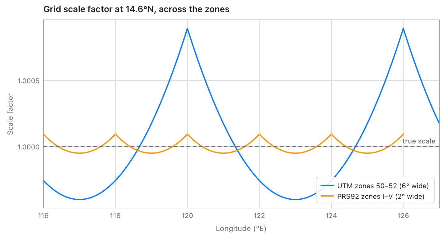
Degrees as text and MGRS
| Function | Gives |
|---|---|
readAngle(text) |
Degrees from 14.5995, 14°35'45.2"N, 14 35 45.2 S, N14°35.753', 121:30:00E, 121d30m15s W, 40d30'N… |
readLatLon(text) |
(latitude, longitude) from 14.5995, 120.9842, 14°35'58.2"N 120°59'03.1"E, N14 35 58.2 E120 59 03.1… |
formatAngle(degrees, style:, decimals:, hemispheres:) |
14°35'58.20"N (.degreesMinutesSeconds), 14°35.9700' (.degreesMinutes) or 14.5995° (.decimal). |
formatLatLon(lat, lon, style:, decimals:) |
14°35'58.20"N 120°59'03.12"E. |
toMGRS(lat, lon, precision:) |
51PTS8284814992: 5 digits for 1 m, fewer for larger squares; UPS letters near the poles. |
fromMGRS(text, center:) |
The south-west corner (or middle) of an MGRS square. |
Mistakes
Points that can't be (a latitude past 90°, NaN) stop the program with a
message, like geodesy: inverse: a latitude must be from -90 to 90….
Reading text returns a Result that says what's wrong: "frob" isn't an ellipsoid PROJ knows, geodesy doesn't have the projection "robin",
"51PZZ" isn't a 100 km square of zone 51, minutes and seconds must be below 60.
Speed
On an Apple M5 Pro: 100 000 transforms through a datum shift (WGS84 to PRS92 zone 3) take 0.13 s, and 100 000 geodesic distances 0.28 s.
Tests
tessel run tests
checks 142 230 values: the cases in tests/cases.json and more by hand.
- 2400 geodesics on WGS84, Clarke 1866, a sphere, and very flat and prolate ellipsoids (nearly antipodal points, poles, the equator, meridians, coincident points), 200 lines, 300 polygons (lots to continents, across 180°, round the poles) and their tracks, against GeographicLib.
- 300 rhumb lines, against SciPy's quadrature.
- Every one of the 5230 EPSG projected systems at random points in its area,
forward and back (Laborde's and Colombia urban's inverses are formulas
that miss by up to a millimetre, as PROJ's do; geodesy matches PROJ's); 287 datums' shifts to WGS84, both by their Helmert and
by PROJ's own EPSG transformation; 297 transforms between systems on
different datums; and 600 systems read from PROJ strings and WKT (GDAL,
Esri and WKT2, with and without EPSG codes; one system of each method
always among them), written back and read again; and PROJ strings for
what no EPSG system uses (polar and spherical azimuthal equidistant,
Hotine by two points or without rotation, Krovak's
+czech…). All against PROJ 9.3 through pyproj. - 1500 MGRS references against the mgrs package.
.venv/bin/python tools/gen/gen.py makes tables.tsl from PROJ's database,
and .venv/bin/python tools/oracle/oracle.py the cases (they need pyproj,
geographiclib, mgrs and scipy in .venv).
What's where
| File | |
|---|---|
geodesic.tsl |
Ellipsoid, ellipsoid, Karney's geodesics, GeodesicLine, polygonArea, trackLength. |
rhumb.tsl |
Rhumb lines, and the meridian arc. |
projections.tsl |
Projection and every projection's formulas. |
crs.tsl |
Crs, datum shifts, transform, EPSG, PROJ strings, UTM zones. |
wkt.tsl |
Reading and writing WKT. |
text.tsl |
Degrees as text. |
mgrs.tsl |
MGRS. |
ellipsoids.tsl |
wgs84(). |
tables.tsl |
Ellipsoids, units, meridians and the EPSG systems, from PROJ (generated). |
examples/ |
Draws the pictures in docs/ with the chart library: tessel run examples. |
tools/ |
Make the tables and the test cases. |
Licence
MIT: see LICENSE. The geodesic algorithms are C. F. F. Karney's
(GeographicLib, MIT). The EPSG data in tables.tsl are from the EPSG
Geodetic Parameter Dataset (© IOGP) as PROJ ships it.